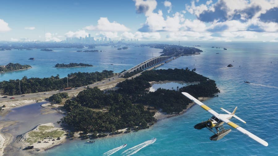
How big is GTA 6's map? It's the most-asked question about the game, and the honest answer is more interesting than a single number. Rockstar has officially named six regions of the state of Leonida. Fan mapping projects have already identified seventeen more, and the community database now tracks over 1,500 individual landmarks — 411 of them named, the rest still marked with a question mark. Here's what Rockstar has confirmed, what the community has estimated from trailer analysis, and how Leonida compares to GTA 5's Los Santos and Blaine County.
What Rockstar Has Officially Confirmed
Rockstar has confirmed the setting: Vice City and the wider state of Leonida. Trailers have shown dense urban streets, island chains lined with mangroves, swamps thick with wildlife, and an industrial port town. What Rockstar has not done is publish an official size figure in square kilometers. Any number you see online is a community estimate based on scaling trailer coordinates — not a fact from Rockstar.
The Six Official Regions
These are the regions Rockstar has named directly in trailers and official material:
| Region | Inspiration | What's shown in trailers |
|---|---|---|
| Vice City | Modern Miami | Dense urban core, neon, beaches, skyscrapers |
| Leonida Keys | Florida Keys | Tropical islands, causeway bridges, boat ramps |
| Grassrivers | The Everglades | Swamps, airboats, alligators, fracking sites |
| Port Gellhorn | Industrial port city | Docks, cranes, container yards, bridges |
| Hamlet | Rural inland town | Farmland, quiet roads, a beacon tower |
| Kelly County | Northern wilderness | Forests, Mount Kalaga, mountains |
Vice City dominates the trailer footage — the neon beachfront, the downtown skyscrapers, theairport approach shots. Leonida Keys stretches south in tropical island chains connected by bridges. Grassrivers is the swamp interior, with airboats and wildlife. Port Gellhorn is the industrial coast, with shipping container yards and the dual Bocamar Bridge (a real fan-named landmark in our database). Hamlet is the quiet inland — farmland and a beacon. Kelly County climbs north into forests and Mount Kalaga. You can see every confirmed landmark on our interactive Leonida map.
The Seventeen Fan-Discovered Regions
Beyond the six official regions, fans analyzing trailer footage frame-by-frame have identified seventeen additional sub-regions and named areas. ⚠️ These are fan-discovered, not officially confirmed by Rockstar — they come from scrap_coordinates analysis and trailer screenshot comparison against real Florida locations.
| Region | Landmarks tracked | Likely inspiration |
|---|---|---|
| Vice Beach | 287 | Miami Beach (separate district from Vice City proper) |
| Vice-Dale County | 129 | Miami-Dade County, surrounding Vice City |
| Vice City International Airport | 24 | Miami International Airport |
| Port Vice City | 21 | Port of Miami |
| Key Lento | 147 | Florida Keys (a second island chain beyond Leonida Keys) |
| Ambrosia / Ambrosia County | 84 | Agricultural interior (sugar mills, silos, tanks) |
| Watson Bay | 49 | Coastal bay area |
| Waning Sands | 20 | Barrier island / beach |
| Tequesta Key | 14 | Florida barrier island (Tequesta is a real Florida town name) |
| Mariana County | 13 | Inland county (likely central Florida) |
| Leonard County | 9 | Northern rural county |
| Catalan Key | 7 | Island in the Keys chain |
| Mount Kalaga National Park | 3 | National park around Mount Kalaga |
| La Perle | 1 | Single-named location |
| Redhill | 1 | Single-named location |
The largest of these, Vice Beach and Vice-Dale County, are likely sub-districts of the greater Vice City metro area rather than separate regions — similar to how GTA 5's Los Santos was surrounded by Vinewood Hills, Richman, and Rockford Hills. Key Lento, Ambrosia, and Watson Bay are more clearly separate biomes. We're tracking all of them live on the interactive map; as Rockstar reveals more in Trailer 3, we'll mark which fan-discovered names match official ones.
Landmarks: 411 Named, 1,105 Still Unknown
The community database currently tracks 1,516 individual points of interest across all 23 regions. Of those, 411 are named (the community has identified what they are from trailer footage) and 1,105 are marked with a ? — locations clearly visible in trailers but not yet identified.
A few examples of what's been named so far:
- ▸Allied Crystal Sugar Mill, Silo, Tanks, Warehouse — an industrial complex in Ambrosia, suggesting farming and sugar processing is a real in-game activity
- ▸Bocamar Bridge (N) and (S) — a dual-span bridge in Port Gellhorn, the kind of set-piece crossing GTA games use for cinematic moments
- ▸Vake Island — an island in the Leonida Keys chain
- ▸Atlantis Hotel, Akio Hotel — named hotels in Vice Beach and Tequesta Key
- ▸Air Force Radar Station — a military installation on Leonida Keys
- ▸Stiltsville Bridge — a bridge in Vice-Dale County, named after the real-world Stiltsville community in Biscayne Bay
- ▸Blue Crab Bar & Grill — a waterside venue in the Leonida Keys
Every landmark in our database is geotagged against its real-world Florida inspiration where one has been identified, with credibility tags indicating whether it's confirmed, unconfirmed, or flagged "may-not-exist." You can browse, filter, and search all 1,516 on the interactive map.
The Five Ultimate Edition Shops and Where They Sit
If you've read our GTA 6 pre-order guide, you know the Ultimate Edition unlocks five exclusive in-game shops. These shops have physical locations on Leonida's map — and the community has already mapped four of them:
- ▸Rideout Customs — Crosstown, Vice City (car customization)
- ▸Stock 305 — Stockyard, Vice City (lifestyle retail)
- ▸Electric Fang Tattoo — Stockyard, Vice City (tattoo parlor)
- ▸PTT Youngin$ Compound — Southside, Vice City (the playable mission location)
- ▸One-Eyed Willie's — Ambrosia County (a more remote outpost)
- ▸Sara's Unisex Salon — location TBD
That's a useful sanity check for any preorder decision: the Ultimate Edition extras aren't floating in a menu — they're real buildings in real districts, which is what makes the Ultimate tier feel like a place rather than a perk.
Community Estimates: How Big Is Leonida Really?
Fan-made mapping projects using trailer coordinates suggest Leonida could span anywhere from 150 to 200 square kilometers of playable terrain — roughly two to three times the size of GTA 5's 75 square kilometers. These are estimates, not confirmed figures.
For context, here's how that would stack up against earlier Rockstar maps:
| Game | Approximate map size |
|---|---|
| GTA 4 (Liberty City) | ~16 sq km |
| GTA San Andreas | ~45 sq km |
| RDR2 | ~50 sq km |
| GTA 5 (Los Santos + Blaine County) | ~75 sq km |
| GTA 6 (Leonida, estimated) | 150–200 sq km |
⚠️ Treat every km² number for GTA 6 as a rumor until Rockstar confirms. The 150-200 figure comes from calculating distances visible in trailer shots (a known building X meters apart from another known building, scaled against their real-world Miami inspirations) and extrapolating across the entire state. It could be off either way.
Why Density Matters More Than Area
The raw square-kilometer number isn't the real story. What makes Leonida feel massive is density — how much there is to do per square kilometer. Three numbers tell that story:
- ▸700+ enterable interiors confirmed. Shops, bars, homes, restaurants — over seven hundred. GTA 5 had fewer than twenty. The effective playable space is much larger than any map comparison can show.
- ▸Multilingual citizens. Vice City neighborhoods include Spanish-speaking and Haitian Creole-speaking areas, mirroring the real Miami. This isn't just flavor — it's tied into the language-based progression mechanic some have speculated about (read our analysis). Talking to NPCs in different languages opens different missions and side activities, which only works because every district has its own linguistic texture.
- ▸Varied biomes. Alligators and airboats in Grassrivers, beaches and pool clubs on Vice Beach, freighters and container yards at Port Gellhorn, forests and mountains in Kelly County. Each biome has its own wildlife, vehicles, and activities specific to it — not just different wallpaper.
Verticality is the third dimension people miss: skyscrapers in downtown Vice City, diveable ocean depths offshore, the climb up Mount Kalaga. Square-kilometer comparisons are a 2D number in a 3D space.
GTA 6 vs GTA 5: Side by Side
| Feature | GTA 5 (Los Santos + Blaine County) | GTA 6 (Leonida) |
|---|---|---|
| Total area | ~75 sq km | 150–200 sq km (⚠️ estimated) |
| Official regions | 1 city + 1 county | 6 official + 17 fan-discovered |
| Tracked landmarks | N/A | 1,516 (411 named) |
| Enterable interiors | under 20 | 700+ ✅ |
| Wildlife variety | Limited (dogs, birds, fish) | Alligators, airboats, swampland ecology, coastal + forests |
| Languages spoken | English only | English + Spanish + Haitian Creole |
| Verticality | Some (Vinewood Hills, Mount Chiliad) | Skyscrapers + ocean depths + Mount Kalaga |
| Protagonists | 3 (Michael, Franklin, Trevor) | 2 (Jason + Lucia, series' first female lead) |
Each GTA 6 row is marked ✅ where officially confirmed or ⚠️ where it's a community estimate or trailer-derived inference.
Where the Characters Operate
Map size matters because it gives the story room to move. Lucia Caminos comes out of Leonida Penitentiary; her path crosses with Jason Duval, who runs smuggling operations along the shallow coasts of the Leonida Keys. The criminal conspiracy the trailers have teased "stretches across the entire state of Leonida" — meaning Jason and Lucia move through every region above over the course of the story.
Supporting characters tie to specific districts: Boobie Ike runs clubs and a property empire in Vice City; Dre'Quan Priest, Real Dimez, Brian Heder, and Cal Hampton all show up in Rockstar's official character materials, each tied to a part of the map. The map isn't a backdrop for the story — it shapes which characters appear where. (Full character breakdown at Jason & Lucia: Everything We Know.)
30 FPS and Map Density
The 30-frames-per-second lock on standard PS5 and Xbox Series X at launch has been one of the more controversial surprises around GTA 6 (full analysis here). The most plausible explanation for the frame rate cap is what the trailers render: ray-traced global illumination across dense tropical wetlands, bright city streets, and lush beaches — environments that are visually heavier per square meter than anything in GTA 5. Leonida is rendering a lot of detail per kilometer, and the 30 FPS cap is likely what makes that density possible on current-gen hardware.
⚠️ This is a community inference, not an official Rockstar explanation. A 60 FPS mode may arrive later (a PS5 Pro patch is the obvious candidate), but on launch day the trade-off is clear: scale and fidelity in exchange for frame rate.
Bottom Line
It's bigger — that much is certain. The exact square-kilometer figure won't be known until someone actually plays it on November 19. But based on everything shown so far — six official regions, seventeen more fan-discovered, 1,500+ tracked landmarks, 700+ enterable interiors, varied biomes from swampland to skyscrapers — Leonida is shaping up to be the most varied open world Rockstar has ever built. We're tracking every confirmed location on our interactive Leonida map. For a full list of what the trailers have revealed so far, see our everything confirmed from the trailers breakdown.
Frequently Asked Questions
How big is the GTA 6 map?
Fan estimates based on trailer coordinate analysis put Leonida between 150 and 200 square kilometers — roughly two to three times the size of GTA 5's 75 square kilometers. ⚠️ This is an estimate, not an official Rockstar figure.
Is the GTA 6 map bigger than GTA 5?
Yes, almost certainly — but the exact margin won't be known until launch on November 19, 2026. Based on the number of regions (23 tracked) and enterable interiors (700+) compared to GTA 5's 1 city + 1 county and fewer than 20 interiors, Leonida is significantly larger in scope.
How many regions are in GTA 6?
Six regions are officially confirmed by Rockstar: Vice City, Leonida Keys, Grassrivers, Port Gellhorn, Hamlet, and Kelly County. Fans have identified seventeen additional sub-regions through trailer analysis, including Vice Beach, Vice-Dale County, Key Lento, Ambrosia, Watson Bay, and others.
How many enterable buildings are in GTA 6?
Over 700 enterable interiors have been reported, including shops, bars, homes, and restaurants. GTA 5 had fewer than twenty enterable interiors by comparison. The exact number will be confirmed at launch.
Does GTA 6 have the biggest map in Rockstar history?
Likely. RDR2's map is approximately 50 square kilometers; GTA 6's Leonida is estimated at 150-200 square kilometers. If the community estimates hold, GTA 6 will be the largest open world Rockstar has ever shipped — but the official figure won't be known until November 19, 2026.
Where is GTA 6 set?
GTA 6 is set in Vice City and the wider state of Leonida — a fictionalized version of Florida. The setting spans urban Vice City (Miami-inspired), the Leonida Keys (Florida Keys), Grassrivers (Everglades), Port Gellhorn (industrial port city), Hamlet (rural inland), and Kelly County (northern wilderness), with additional fan-discovered regions including Vice Beach, Key Lento, and Ambrosia.